LAS VEGAS, Nov. 15, 2017 /PRNewswire/ -- Autodesk, Inc. and Esri, Inc. today announced the start of a new relationship to build a bridge between BIM and GIS mapping technologies. Together Autodesk and Esri plan to enable a broad range of industries to gain better context by visualizing data of the man-made world, the environment, citizens and the networks that weave it all together.


"It is important to consider the needs of future generations during the design and building of projects today," said Jack Dangermond, President, Esri. "The benefits of partnering with Autodesk will include securing sustainable resources for the growing population, a responsible human footprint on our natural environment, better use of our planet's resources and more resilient cities."
For infrastructure owners around the world, both public and private, enabling BIM and GIS mapping software to more seamlessly work together will optimize their ability to plan, design, build and operate infrastructure assets saving precious time and money. Improving the integration of Esri and Autodesk software has the potential to dramatically decrease workflow times.
"Partnering with Esri is intended to combine the power of BIM and GIS mapping which will enable our shared customers to build anything, anywhere," said Andrew Anagnost, CEO, Autodesk. "Our goals are to provide industry and city planners the ability to design in the context of the real world. This will allow communities to build more connected, resilient cities, and infrastructure with a focused eye on sustainability."
Autodesk and Esri plan to work together to better integrate their respective technologies, allowing industry professionals to synthesize information from both BIM and GIS to enable a more connected infrastructure. Benefits are expected to include unprecedented reductions in permitting through improved stakeholder engagement, more sustainable and resilient design through enhanced project insight, and reduced risk via improved end-to-end flow of materials, resource availability and scheduling during construction.
"I'm thrilled to learn of the Autodesk and Esri strategic partnership," said John Kizior, Global Director, Project Technologies. "At AECOM, we value innovative spirit, and I'm optimistic that this new strategic partnership will produce dynamic software synergies. The combined technology sets has the potential to provide new ways of connecting information across the project lifecycle to the benefit of our clients."
The world is expected to add 2.5 billion more people in the next 30 years, 70 percent whom will reside in urban areas, putting extraordinary pressure on already strained infrastructure resources and requiring an infrastructure spend of US$3.3 trillion per year. To meet these challenges, the public and private sectors must find ways to streamline the entire transportation and infrastructure building lifecycle. The planned improvements to the integration of Esri and Autodesk software will change the way we build our future. It establishes a readiness to Make Anything, Anywhere – with The Science of Where.
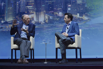
This vision was announced by Andrew Anagnost and Jack Dangermond at Autodesk's annual flagship user event, Autodesk University, in Las Vegas, Nevada. To learn more, please visit the Autodesk and Esri collaboration page.
About Autodesk
Autodesk makes software for people who make things. If you've ever driven a high-performance car, admired a towering skyscraper, used a smartphone, or watched a great film, chances are you've experienced what millions of Autodesk customers are doing with our software. Autodesk gives you the power to make anything. For more information visit autodesk.com or follow @autodesk.
About Esri
Esri, the global market leader in geographic information system (GIS) software, offers the most powerful mapping and spatial analytics technology available. Since 1969, Esri has helped customers unlock the full potential of data to improve operational and business results. Today, Esri software is deployed in more than 350,000 organizations including the world's largest cities, most national governments, 75 percent of Fortune 500 companies, and more than 7,000 colleges and universities. Esri engineers the most advanced solutions for digital transformation, the Internet of Things (IoT), and location analytics to inform the most authoritative maps in the world. Visit us at esri.com.
Copyright © 2017 Esri. All rights reserved. Esri, the Esri globe logo, The Science of Where, esri.com, and @esri.com are trademarks, service marks, or registered marks of Esri in the United States, the European Community, or certain other jurisdictions. Other companies and products or services mentioned herein may be trademarks, service marks, or registered marks of their respective mark owners.
Autodesk is a registered trademark or trademarks of Autodesk, Inc., and/or its subsidiaries and/or affiliates in the USA and/or other countries. All other brand names, product names or trademarks belong to their respective holders. Autodesk reserves the right to alter product and services offerings, and specifications and pricing at any time without notice, and is not responsible for typographical or graphical errors that may appear in this document.
© 2017 Autodesk, Inc. All rights reserved.
SOURCE Autodesk, Inc.


Share this article